 |
|
Interactive map of St Kitts Key Island Info
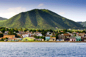
St Kitts History & Facts St Kitts (also known as St Christopher) was settled by the British in the year 1623 and became an associated state with full internal autonomy in 1967. The federation originally consisted of St Kitts, Nevis and Anguilla, however in 1971 the island of Anguilla rebelled and was allowed to secede. St Kitts and Nevis became independent form Britain on 19th September 1983. The coastline of St Kitts can loosely be classed as the shape of a guitar, and the island is separated from the sister island Nevis by a 3km-wide channel called “The Narrows”. The long thin section and head of the island is called the South east peninsular, here lies the Great Salt Pond, and in this area the best beaches on the island can be found. The island's point of highest elevation is Mt. Liamuiga, at 3,792 feet. Nevis, the smaller island, lies to the south and is approximately 7 miles in diameter, covering a total of 36 square miles. The majority of the island live within the flatter section of the island directly adjacent to the coast, the steeper interior consists of agricultural lands at lower levels eventually giving way to lush tropical forests. The agricultural lands at the base of tropical rain forests until recently were predominantly sugar cane fields, however due to changes in market conditions and the dramatic reduction in Sugar prices, it was felt that this industry is no longer viable. The main industries in St Kitts today are tourism, financial services, light industry, agriculture and various service industries. St Kitts is a beautiful peaceful island, as with many other Caribbean islands it is quite laid back, however St Kitts has quite a unique character that is not found on other islands. Special consideration is given to the environment, with strict building laws which generally prohibit the construction of building that are taller than surrounding palm trees. Eco tourism is gaining popularity on the island as greater emphasis is being place on protecting our beautiful land. Some of the more popular activities include hiking through the lush rain forests, visiting some of our brilliant tropical gardens, or simply trying to spot one of our elusive green vervet monkeys Other activities that can be undertaken on the island are golfing, fishing, diving or snorkeling and sightseeing to mention but a few. | ||||||||||||||||||||||||||||||||||||||||
|
Web
Master |
| ||||||||||||||||||||||||||||||||||||||||